

InsightAce Analytic Pvt. Ltd. announces the release of a market assessment report on the “Global Drone Application Map Tool Market Size, Share & Trends Analysis Report By Use-Case Application (Input Application Mapping, Aerial Seeding and Replanting Guidance, Crop Scouting and Vegetation Monitoring, Irrigation and Water Stress Mapping, Regulatory Compliance and Documentation, and Livestock Monitoring), By Software (Application Map Generation Tools, Mission Planning and Execution Software, Compliance and Traceability Software, and Drone-Based Agronomic Analytics Software), By Integration Level (Standalone Mapping Tools, and Integrated Farm Management Systems), By Deployment Model (Cloud-Based Platforms, and On-Premises/Desktop Software), By Business Model (Software-as-a-Service (Subscription), Pay-Per-Use (Per Acre or Per Flight), and Enterprise Licensing and Service Contracts),-Market Outlook And Industry Analysis 2034″
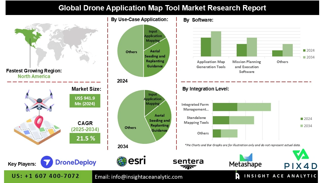
Global Drone Application Map Tool Market Size is valued at US$ 941.9 Mn in 2024 and is predicted to reach US$ 6,428.7 Mn by the year 2034 at an 21.5% CAGR during the forecast period for 2025-2034.
Get Free Access to Demo Report, Excel Pivot and ToC: https://www.insightaceanalytic.com/request-sample/3220
The Drone Application Map Tool offers a wide range of applications, including precision agriculture for crop monitoring, infrastructure inspection, urban planning, disaster management, environmental monitoring, and logistical mapping. It enhances data collection and enables real-time data analysis, supporting more informed decision-making and operational efficiency. By leveraging these capabilities, industries can optimize processes, reduce costs, and improve safety and accuracy.
The market for Drone Application Map Tools is experiencing growth due to the rising demand for precise, real-time geospatial data across sectors such as agriculture, construction, mining, and environmental monitoring. The increasing deployment of unmanned aerial vehicles (UAVs) for mapping, surveying, and inspection purposes is driving market expansion by delivering operational efficiencies, cost savings, and enhanced safety. Technological advancements in high-resolution optical sensors, near-infrared imaging, LiDAR, and artificial intelligence-driven analytics are facilitating easier adoption and greater value from drone mapping solutions.
Furthermore, government initiatives promoting smart cities, precision agriculture, and infrastructure development are accelerating the adoption of UAV-based mapping tools. The growing recognition of drones’ role in disaster management and resource optimization is further reinforcing rapid market uptake and contributing to sustained industry growth.
List of Prominent Players in the Drone Application Map Tool Market:
- Pix4D SA
- DroneDeploy, Inc.
- Agisoft LLC (Metashape)
- Sentera, Inc.
- Environmental Systems Research Inst. (ESRI)
- Aerobotics (Pty) Ltd
- Hummingbird Technologies Ltd
- Hiphen Technologies
- Farmonaut
- OpenDroneMap, Inc. (open-source)
- SPH Engineering LLC (UgCS)
- DroneMapper LLC
- Maps Made Easy, Inc.
- SimActive Inc.
- FlyPard Analytics GmbH
Read Overview Report- https://www.insightaceanalytic.com/report/drone-application-map-tool-market/3220
Market Dynamics
Drivers:
The global Drone Application Map Tool market is being driven by increasing demand for high-precision mapping and surveying solutions across diverse sectors, including agriculture, construction, mining, and urban planning. Technological advancements in drones, sensors, LiDAR, and AI-powered data analytics are enhancing mapping accuracy and operational efficiency. The growing deployment of UAVs for real-time monitoring, infrastructure inspections, and disaster management is reducing labor costs and mitigating safety risks.
Additionally, government initiatives supporting smart cities, precision agriculture, and environmental monitoring are contributing to market growth. The rising need for sustainable resource management, rapid decision-making, and cost-effective surveying solutions is further accelerating the adoption of drone-based mapping technologies on a global scale.
Challenges:
Market expansion is constrained by regulatory restrictions and complex airspace regulations, which limit commercial drone operations in several regions. High initial investments in drones, software, and sensor systems can hinder adoption among small and medium-sized enterprises (SMEs). Collecting geospatial information at small to medium scales raises privacy and data security concerns, while operational limitations such as battery capacity and payload constraints in adverse weather conditions further challenge deployment. A shortage of skilled personnel for drone operation and geospatial data analysis also impedes market growth. Moreover, limited interoperability between drone platforms and mapping software can restrict seamless integration. Collectively, these factors may slow market expansion.
Regional Trends:
In 2024, North America led the Drone Application Map Tool market, driven primarily by the United States. Market leadership is supported by the early adoption of advanced UAV technologies, robust infrastructure, and established industries in construction, agriculture, and mining. Supportive government policies, investments in smart city initiatives, and strong demand for precision mapping solutions, alongside the presence of leading drone manufacturers and technology innovators, reinforce the region’s dominance.
The Asia-Pacific region presents significant growth opportunities due to rapid industrialization, urbanization, and infrastructure development. Rising adoption of drones across agriculture, mining, and disaster management, coupled with favorable government regulations, technological advancements, and increasing investment in smart city and precision agriculture projects, is driving market expansion. Additionally, growing awareness of the advantages of drone mapping and the presence of substantial untapped markets are expected to fuel strong growth in the region.
Unlock Your GTM Strategy: https://www.insightaceanalytic.com/customization/3220
Recent Developments:
- July 2025: Pix4D launched PIX4Dfields 2.10, introducing AI-powered boundary and obstacle selection along with new spray drone export capabilities. These enhancements streamline prescription map workflows, enabling faster, more accurate agricultural planning and crop management.
Segmentation of Drone Application Map Tool Market-
By Use-Case Application-
- Input Application Mapping
- Aerial Seeding and Replanting Guidance
- Crop Scouting and Vegetation Monitoring
- Irrigation and Water Stress Mapping
- Regulatory Compliance and Documentation
- Livestock Monitoring
By Software-
- Application Map Generation Tools
- Mission Planning and Execution Software
- Compliance and Traceability Software
- Drone-Based Agronomic Analytics Software
By Integration Level-
- Standalone Mapping Tools
- Integrated Farm Management Systems
By Deployment Model-
- Cloud-Based Platforms
- On-Premises/Desktop Software
By Business Model-
- Software-as-a-Service (Subscription)
- Pay-Per-Use (Per Acre or Per Flight)
- Enterprise Licensing and Service Contracts
By Region-
North America-
Europe-
- Germany
- The UK
- France
- Italy
- Spain
- Rest of Europe
Asia-Pacific-
- China
- Japan
- India
- South Korea
- South East Asia
- Rest of Asia Pacific
Latin America-
- Brazil
- Argentina
- Mexico
- Rest of Latin America
Middle East & Africa-
- GCC Countries
- South Africa
- Rest of Middle East and Africa
About Us:
InsightAce Analytic is a market research and consulting firm that enables clients to make strategic decisions. Our qualitative and quantitative market intelligence solutions inform the need for market and competitive intelligence to expand businesses. We help clients gain competitive advantage by identifying untapped markets, exploring new and competing technologies, segmenting potential markets and repositioning products. Our expertise is in providing syndicated and custom market intelligence reports with an in-depth analysis with key market insights in a timely and cost-effective manner.
Contact us:
InsightAce Analytic Pvt. Ltd.
Visit: https://www.insightaceanalytic.com/
Tel : +1 607 400-7072
Asia: +91 79 72967118
info@insightaceanalytic.com


